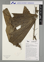
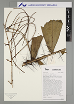
| Field notes | Solitary understory palm. Stem 1.5 m high, 4 cm thick; internodes 5 cm long, brown, spiny. Base of stem with few visible roots. Leaves 10; sheath 15 cm long, open, with 3 cm long black spines; petiole 5 cm long, section round, with 6 cm long black spines; rachis 110 cm long, with 5 cm long black spines; lamina pinnate, 130 cm long, 40 cm wide, bushy, glabrous; pinnae 11-12 per side, irregularly inserted in groups of 2-3; basal pinna 12 cm long, middle pinna 20 cm long, apical pinna 21 cm long. Inflorescence interfoliar; prophyll 30 cm long, 2 cm wide, herbaceous; peduncular bract 105 cm long, inserted 20 cm from base, brown, herbaceous to papery; peduncle 80 cm long, 1 cm wide, with 5 cm long brown spines; rachis 30 cm long, 0.5 cm wide; rachillae 19, 30-58 cm long. Flowers cream to purple, sessile. Fruits cream to purple, 0.7 cm long, 0.6 cm wide. Silicagel sample taken. Transect: HB 764, from transect |
 This record