AAU Herbarium Database |
| New Search Modify Search |
| Type of: | Sciodaphyllum balslevii Lowry, G.M.Plunkett, M.M.Mora & D.A.Neill |
| Collector | Neill, D. |
| Number | 18710 |
| Collected with | Porter P. Lowry II, Gregory M. Plunkett & Efren Merino |
| Country | Ecuador |
| Subpart | Tungurahua |
| County | |
| Locality | Baños Canton. Langanates National Park, ca. 8 km north of Baños-Mera highway. Watershed of Río Zuñac, along trail ascending ridge towards crest of Cordillera Abitagua, about 3 km above the boundary of the national park with the Río Zuñac reserve of Fundación EcoMinga. Very wet cloud forest with abundant epiphytes; granite substrate. With students in the "Tropical Botany" field course, part of the project "Systematics and Evolution of the Neotropical clade of Schefflera s.l. (Araliaceae)". |
| Coordinates | 1° 29' 59'' S 78° 8' 1'' W |
| Minimum elevation (m) | 2488 |
| Maximum elevation (m) | 2488 |
| Start date | 2019/01/10 |
| End date | 2019/01/10 |
| Family | Araliaceae |
| Identification | Sciodaphyllum balslevii Lowry, G.M.Plunkett, M.M.Mora & D.A.Neill |
| Determined by | P.P. Lowry II |
| Identification qualifier | |
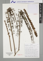
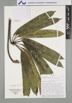
| Field notes | Sparesly branched tree ca. 3 m tall. Leaves dark green above, paler beneath, bundle-compound, with the leaflets forming a regular whorl, the petiole, petiolules, midvein and margins dark reddish-purple. Inflorescence axes and pedicels dark reddish purple. Buds and flowers pale yellow green, ovary with dense ferruginous indument, calyptrate corolla tinged light reddish-purple, filaments pale yellow-green, anthers reddish-purple. Immature fruits arranged radially in umbellules, ovary dark brownish-purple, calyx rim and minute teeth lighter, disc white tinged deep pinkish-purple, styles darker, stylar branches 2. DNA |
| |
 This record This record Other records of Sciodaphyllum balslevii Other records of Sciodaphyllum balsleviiThe map displays only records from the Aarhus Herbarium Database. The records may not represent the full distribution of Sciodaphyllum balslevii |
| New Search Modify Search |