| Collector | Neill, D. |
| Number | 16368 |
| Collected with | James Aronson |
| Country | ECUADOR |
| Subpart | Zamora-Chinchipe |
| County | |
| Locality | Cordillera del Cóndor, western slopes. Lower Río Wawaime valley, tributary of Río Quimi. Deforested pasture on rocky slope with remnant trees. EcuaCorriente copper mine concession. |
| Coordinates | |
| Minimum elevation (m) | 850 |
| Maximum elevation (m) | 0 |
| Start date | 2008/05/04 |
| End date | 0/00/00 |
| Family | Fabaceae |
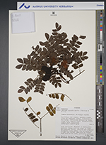
| Identification | Abarema jupunba (Willd.)B.& K. |
| Determined by | |
| Identification qualifier | |
| Field notes | Tree 10 m tall. Remnant in deforested pasture. Stony soil on slope in lower Río Wawaime valley. Corolla and staminal filaments ivory-white. Pod at maturity bright red inside. Dehisces to reveal dark blue-black seed, partially covered |
|