| Collector | Ollgaard, B. |
| Number | 3053 |
| Collected with | H. Navarrete |
| Country | Ecuador |
| Subpart | TUNGURAHUA |
| County | |
| Locality | Tall wet montane forest W of Río Guambi, ca. 7 km along road and trails S of Río Negro. |
| Coordinates | 1° 27' S 78° 15' W |
| Minimum elevation (m) | 1780 |
| Maximum elevation (m) | 1830 |
| Start date | 1998/04/02 |
| End date | 1998/04/03 |
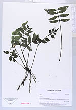
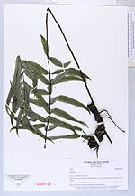
| Family | Marattiaceae |
| Identification | Danaea betancurii A.Rojas |
| Determined by | H. Turmisto & J. Keskiniva |
| Identification qualifier | |
| Field notes | On steep soil bank, rhizome ascending, roots unilateral. |

|
 This record
 Other records of Danaea betancurii