AAU Herbarium Database |
| New Search Modify Search |
| Collector | Lojtnant, B. |
| Number | 12306 |
| Collected with | Molau, U. & Madison, M. |
| Country | Ecuador |
| Subpart | CARCHI |
| County | |
| Locality | Summit of road from Playón de San Francisco to El Carmelo. Virgin cloud forest. |
| Coordinates | 0° 38' N 77° 38' W |
| Minimum elevation (m) | 3200 |
| Maximum elevation (m) | 3200 |
| Start date | 1979/04/12 |
| End date | 1979/04/12 |
| Family | Orchidaceae |
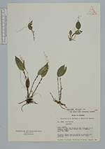
| Identification | Lepanthes peniculus Luer |
| Determined by | C. A. Luer (SEL), 1983 |
| Identification qualifier | |
| Field notes | Epiphyte. Sepals hyaline whitish to whitish pale greenish. Petals and gynostemium dark violet purplish. |
| |
 This record This record Other records of Lepanthes peniculus Other records of Lepanthes peniculusThe map displays only records from the Aarhus Herbarium Database. The records may not represent the full distribution of Lepanthes peniculus |
| New Search Modify Search |